It would be an understatement to say we are overwhelmed by data. The technology to acquire tidal waves of data is upon us: seismic, well logging, production monitoring, microseismic, time-lapse seismic, environmental elements, plus the layers of "meta-data" that accompany each data type. We are literally struggling to catch up, let alone keep pace. I don’t know of anyone who has demonstrated the kind of unequivocal mastery over all their data necessary to make it perform, dynamically, on demand, the elegantly choreographed, integrated dance we have in our imagination. Loose ends, incomplete systems, human error, false correlations, misleading biases, broken connections, bottlenecks, sampling gaps, communication failure, and much more are the truly messy reality.
As scientists, we are accustomed to making recommendations and decisions on incomplete data. In fact, let’s be honest with ourselves and admit, up front, that we never have and never will have 100% complete or 100% reliable data. Yet we can’t be paralyzed by doubt; we still need to make technical judgments, operational decisions, and economic choices, like we do in real life every day. How do we filter, assess, categorize and ultimately benefit in the midst of all this uncertainty?
Do you know that if you do a map of well-log quality, you reveal geology? Or if you use the residual error in a seismic inversion process as an attribute, it correlates to rock properties? Not only should we be using and understanding the data characteristics we specifically know to look for, we also have to be open to finding meaning where we don’t expect it. At the same time, the observations we do make can be biased. There is a shiny new building in downtown Calgary that is a simple glass rectangle with rounded corners. It’s a tall building relative to its neighbours, but if you look closely, they have reduced the size of the windows on the higher floors, which has the effect of making it look even taller than it is. From street level, we significantly misjudge the height. Many of our geoscience observations are from ‘street level’, and therefore biased by that perspective. Literally and figuratively, we need to be open to different points of view.
Geoscientists and their friends fall into two polarized camps these days: the ‘machine learning/AI will replace humans’ camp and the ‘a computer can’t possibly learn the kind of creativity required to do geology’ camp. Neither is right. If the two camps all got together in a crowded room, it would be like the chocolate-lover and the peanut butter-lover bumping into each other in the street and creating my favorite sweet treat, the Reese’s peanut butter cup! The whole is definitely tastier than the sum of its parts.

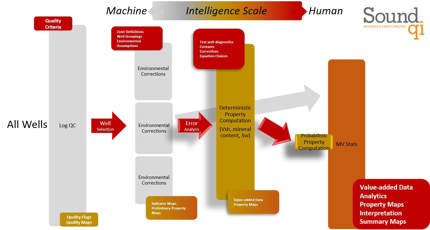
Consider a petrophysical example. Talk to any petrophysicist and they will tell you that there is a lot of judgement and creativity involved in interpreting well logs. That’s true, but if you break down their workflow into small pieces, each piece is actually a combination of mechanical process and judgement. Just like we parallelized computations in multi-core CPU’s or the cloud, we can do petrophysical analysis in parallel. But only if we decouple the process from the judgement. The process can then be done by a computer, and the judgement by the human petrophysicist. The figure shows how we identify and code the process part, but assess inputs and outputs using human skill and experience, and then turn the whole workflow sideways to realize monumental time-saving, effective use of all data, and better decisions as a result. This decoupling of process and judgement in a sideways workflow can be done with every data procedure we undertake, effectively unleashing the power of the computer, but, at the same time, remaining firmly in charge.
Using this approach, we were able to transform a task that had no hope of ever being complete by a human alone to full completion in a matter of hours, without any loss of integrity. Imagine how much more thought and quality time can go into the very human creative endeavours of sensitivity testing, geological scenario investigation and development planning when the data is distilled before your eyes.


